Flood Risk Management for Municipal and Land Development Projects
Why Understanding Flood Risk Matters
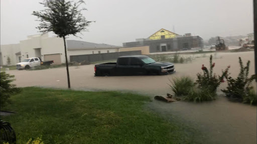
For most people, the term “flood” conjures up images of half-submerged cars and neighborhood streets resembling rivers due to excessive rainfall. In civil and municipal engineering, though, managing flood risk involves far more than just preparing for a rainy day. Protecting lives and property from the dangers posed by flooding requires a great deal of strategic planning, technical expertise, and a thorough understanding of the mechanics of how water flows across the land.
It also demands a comprehensive knowledge of federal, state, and local regulations regarding flood risk and floodplain management. At the federal level, FEMA sets the standards, as well as the terms of the National Flood Insurance Program (NFIP), which guide local authorities in crafting the rules governing development and mapping Special Flood Hazard Areas (SFHAs).
Why People Underestimate Flood Risk
Property owners and developers may see flood regulations as an imposition – a restriction on property use, preventing them from fully realizing the potential of their land. Why should seemingly overly strict regulations, made by distant bureaucrats, determine what can be done with land that appears buildable on a sunny day? But add a flood, and suddenly that “buildable” land is under six feet of rushing water.
Many people think the risk is exaggerated. They’ll point to the odds – “a 1% chance flood” or “one of those 500-year floods.” But here’s the reality: those numbers don’t mean you’re safe for centuries. A “hundred-year flood” is just the math of probability. It means the flood has a 1 in 100 chance of occurring every year. It could happen this year, and again next year. However, based on the long-term average, it will occur once every 100 years.
What Is a Floodplain?
A floodplain is just the low-lying land next to rivers, creeks, or other waterways. That’s where water spreads out when levels rise. FEMA draws the official lines on maps to alert people as to where those flood zones are.
To a landowner, it may feel arbitrary: “My property’s never flooded in 40 years – why should I care about that blue line on a map?” But engineers know the science says otherwise. Risk doesn’t care about your anecdotal experience. Flood waters don’t care about what happened last year.
Looking at Risk: Maps, Models, and More
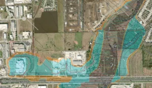
For landowners and developers, floodplain maps are usually the starting point for understanding floodplain risk. FEMA publishes them, sometimes with updates. They can also be corrected and revised with Letters of Map Revision (LOMRs) or Amendments (LOMAs).
The mapping process involves rigorous calculations and analyses. Engineers create hydraulic models to simulate how water flows and runs through sites to forecast flood behaviors and to delineate areas of floodplain risk. These models also help engineers see how rainfall runoff makes its way through detention systems, channels, bridges, and culverts.
What Is a Culvert?
A culvert is usually built under an existing structure, such as a road or railway, to allow water to pass through as a means of flood prevention. Culverts, usually tunnels or pipes, must be designed with the proper dimensions to convey the expected runoff. If a culvert is not properly maintained and kept clear of debris, it can plug, potentially creating a flooding risk.
How Do You Reduce Flood Risk?
Different situations call for different approaches. Some of the common options include:
- Raise it up. Put a building on piers or elevate it on fill so it clears the floodplain. Often, buildings elevated on fill or piers should also account for waves.
- Compensate. If you add fill, you may need to excavate elsewhere to maintain the floodplain’s capacity to pass floodwater.
- Detention or diversion. Detention ponds can be used to control stormwater upstream by throttling or reducing the flow. Various methods, such as dikes, levees, and channelization, may be employed to redirect runoff from flood-prone areas.
- Channel work. Clear brush, cut low branches, or smooth the channel bottom to allow water to pass more quickly at a lower depth.
- Levees and walls. Ridges or other barriers designed to protect areas adjacent to waterways from flooding.
Every option has its downsides. Elevated building works but adds costs. A detention pond might be effective, but takes land away from development. Some flood flows are too large to be reasonably managed with detention.
What Is a Detention Pond?
A detention pond is an artificial basin that can temporarily hold excess stormwater. Unlike a retention pond, which keeps water permanently, a detention pond slowly releases it back downstream. The idea is simple: don’t let all the water hit the system at once. The storage volume in the pond or lake allows the flow to be reduced to downstream areas.
Designing Smarter Infrastructure
Flood risk management often comes down to infrastructure choices:
- Drainage systems that can actually handle the runoff.
- Detention ponds to reduce peak flows.
- Buildings designed for water, with open ground levels or breakaway walls that won’t collapse the whole structure.
- All-weather roads, elevated so emergency vehicles can get through during a 100-year flood.
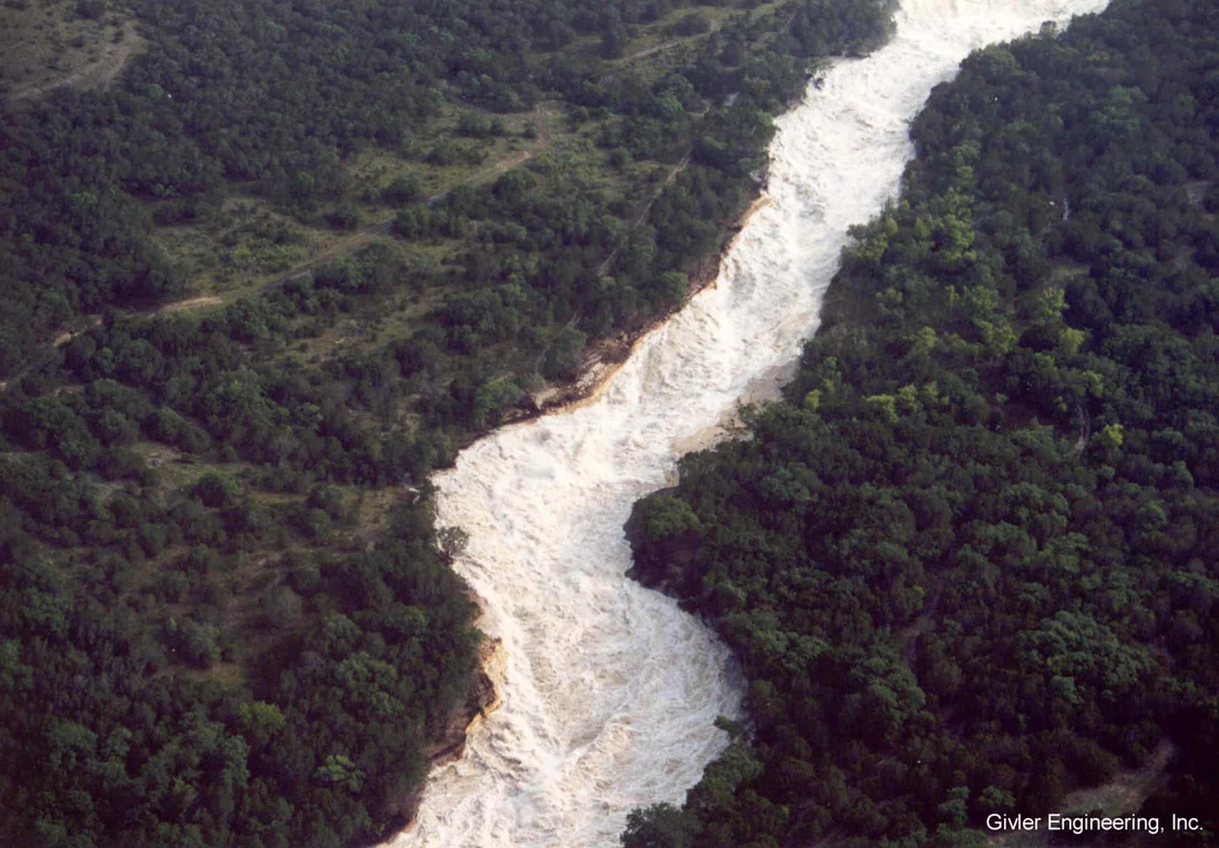
California’s aqueducts and Texas’ flash flood-prone watersheds each tell the same story: if you don’t account for the water, it will eventually hurt you.
Working with the Rules, Not Against Them
Floodplain regulations can feel like a wall, but they’re really guardrails. The trick is to engage early. Talk with FEMA, local floodplain administrators, permitting authorities, and experienced civil engineers before you’re too deep into design.
And sometimes, the maps are just wrong. In San Antonio, one restaurant was forced to close when FEMA’s revised map put it in the floodplain. Upon review, our engineers realized that the model had overlooked upstream detention. By running a corrected model and submitting a LOMR, the team proved the property wasn’t actually at risk. The restaurant eventually reopened—but only after losing a year and a half of business.
Planning for the Future
Flood risk isn’t static. Rainfall patterns change. Droughts often end in violent storms. Climate change may make heavy rainfall more intense. The patterns may shift, but the floods keep coming.
Communities looking ahead should focus on three things:
- Resilient roads. Emergency access routes need to hold up and be accessible in a 100-year flood.
- Education. Flood fatalities occur in multiple settings. Sometimes they occur at bridges and low water crossings. Sometimes they happen in buildings located in the floodplain. People need to understand that risk.
- Careful planning. Respect the maps, the models, and the engineers drawing them.
The Guadalupe River tragedy, which occurred in July 2025, is a painful reminder. The warnings were there. The system was in place. But failures to take the regulations and recommendations seriously resulted in unthinkable catastrophe.
Conclusion: Effective Flood Risk Management Makes All the Difference
Floods are inevitable – it’s just a question of when. The protection of life and property depends on planning and proactive flood management.
The involvement of flood experts during initial development stages and infrastructure projects works to prevent flood-related losses. In this way, planning ahead meets practical needs and helps save lives.
Givler Engineering Inc. offers complete flood risk evaluation, detention pond design, and hydraulic modeling services to help communities be prepared and stay safe. We are intimately familiar with the regulatory process at every level and can assist you in all matters of compliance. Don’t let the next storm catch you off guard. Contact us today to discuss your flood risk management concerns.